Sand Creek Byway Built!

Photo Credit: Idaho Airships Inc, courtesy of URS
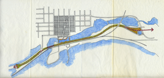
On a recent trip to Spokane, Vicki decided to travel to nearby Sandpoint, ID, to see the Sand Creek Byway that completed on June 29th, 2012. Vicki Scuri SiteWorks’ involvement in the project dates back to 2001, when as part of ITD’s public involvement program, Vicki was invited to join the Washington Group International and CH2M Hill Team Design Team, as a visual site specialist. The project includes 2.1 miles of new alignment connecting U.S. 95 from the northern end of the Long Bridge, directly to Idaho 200 and U.S. 95, north of Sandpoint. It includes six bridges, 65 retaining walls, a pedestrian and bike pathway, and over 3 acres of habitat enhancement. The project diverts heavy truck traffic from the center of town (yellow) to a route following the railroad bypass (green) and significantly reduces congestion in the center of town.

Photo Credit: Idaho Airships Inc, courtesy of URS
By the time Vicki joined the Team, the project had been in development for nearly 2 years. This project had been discussed since the 1940’s and had generated considerable debate among supporters and opponents. When Vicki joined the Team, the project was developed as conventional infrastructure, with concrete columns, bents and slab construction, creating a freeway understory along Sand Creek. Many citizens expressed the feeling that the Byway would destroy the town. The view above shows Bridge Street passing under the new ‘byway’ and railroad and connecting to the Pend Oreille lakefront, a major destination for both locals and tourists.
One of Vicki’s roles was to listen to the community, hearing their concerns, ideas and dreams for this project, applying her creativity to envision a site design solution that celebrated civic identity and place. On August 7th – 10th 2001, she spent four days holding one-on-one interviews with local citizens. The overwhelming consensus was for a green solution with a river walk, providing open space and habitat along the town’s waterfront edge, between Sand Creek and Lake Pend Oreille, creating a greenbelt and green Byway.
Site Sketch by Mark Spitzer
Working with Vicki, Mark Spitzer expressed this idea in an early sketch site analysis, depicting the town, the river walk and the Byway in its larger footprint and proposing a unifying ‘green’ theme from one end to the other that would also connect across Sand Creek to the downtown. The quality of life in Sandpoint is enriched by the Byway, as it removes through traffic from city streets. The Byway provides spectacular views of the town and its surrounds. Vicki credits the Community, the Team and ITD, for having the foresight to embrace the Green Byway Concept, “The Green Ribbon,” in its infancy and for making it a reality. Today, none of us can imagine this infrastructure project built in any other way.
The following sketches and photos show how initial ideas evolved into the finished byway.

City Beach Bridge Sketch by Mark Spitzer
Coincidentally, at that time, on some of our other projects (D Street Bridge in Tacoma, WA) Vicki was exploring MSE green walls as an alternative to conventional infrastructure. Upon the completion of her site review and return to Seattle, Vicki began developing the Green Ribbon Project for the Sand Creek Byway, replacing the conventional structure with MSE green walls, adding a linear park, river walk and signature bridges. Above is one of the early sketches, showing a conceptual design for City Beach Bridge including MSE green walls and stepped decorative walls at the abutment, framing the entry to City Beach.

Above is the built project. Sited in front of the Burlington Northern tracks, wedged between City Beach and the Sand Creek Byway. The Cabinet Mountains rise behind the Sand Creek Byway creating a spectacular backdrop for the town.
The stepped concrete feet of the bridge are planted, adding addition interest as spring approaches. On this sunny winter day many people drove to the site, parked along the greenbelt to the right, and then walked the linear park. In 2011, Rand McNally and USA Today named Sandpoint named the nation’s “Most Beautiful Small Town.” Clearly, the Byway did not destroy the town. It connected it.

Green Wall Sketch by Mark Spitzer
The initial sketches of the Green Byway envisioned a solid green wall, blocking noise and views of the highway, creating a visual buffer to the infrastructure. After consulting with the community, it became clear that the community and town wished to be seen from the highway. The community did not want to be “invisible.” Being seen was and is very important to the town’s economic livelihood. While the citizens welcomed moving the through-traffic off city streets, they also wanted passersby to stop, to have lunch, to linger, to shop, to recreate, to spend the night, and to enjoy the breathtaking scenery of this magnificent environment.

Even in winter, the Sand Creek Byway green wall is beautiful. Vicki talked to many locals who were out strolling the site. The stroll from end-to-end and back takes approximately an hour-and-a-half. In this area of the linear park, the green walls step-in and-out, creating forms that terrace the green wall, providing human scale and definition. Planted with native plants augmented by seeds that blow into the site, the green wall is becoming a rich palette of textures year-round. One woman mentioned the yellow roses, that she had seen further down along the site. She loved them. Everyone Vicki spoke with praised the Byway for its contributions to community life and its functionality. It works!

Sand Creek River Walk Sketch by Mark Spitzer
Above is one of the early drawings of the proposed creek walk with beach extensions, creating a linear park and path that allows people to walk around Sand Creek. While the entire walk has not been implemented, originally, it was the town’s vision to create a river walk similar to San Antonio, TX, connecting retail spaces with recreational spaces and recreational activities. To the left is the Cold Water Creek Mall connecting across Sand Creek to the linear park. On the right, is the entry to City Beach, crossing under the Byway. Most likely, this is an opportunity that is waiting to happen.

Here is the reconstructed Sand Creek Beach. A shoreline extension was developed, providing a landscaped park and access to the waterfront. In the summer, bathers, kayakers and boaters access the creek with the stone steps. This feature is across from one of the major landscaped walls, creating a picturesque pocket park along the way. The stone benches are attractive and comfortable, adding to the natural beauty and muscle of the site.

Over 3 acres of habitat enhancement was developed for the site, offsetting the shoreline extension impacts to the environment. The restoration provides habitat for aquatic species and improved aesthetics. These areas were built up and planted with native species that could survive in the various water depths and seasonal changes that accompany the fluctuation of the lake level. The improvements provide habitat for aquatic, amphibian and bird species. Also, the trail provides an opportunity for recreational activities: strolling, jogging, biking, and more.

MSE Green Wall Sketch by Mark Spitzer
Here is one of the early sketches envisioning the Green Byway. The Byway is constructed on mechanically stabilized earth, later seeded in soil pockets to create a lush green wall throughout the seasons. Without the green wall, the experience in the town and along the trail would be quite different. Instead of having a green buffer, the original infrastructure concept proposed bents and columns that would have created a dark understory at the town’s edge, potentially blighting the experience of river walk and the trail.
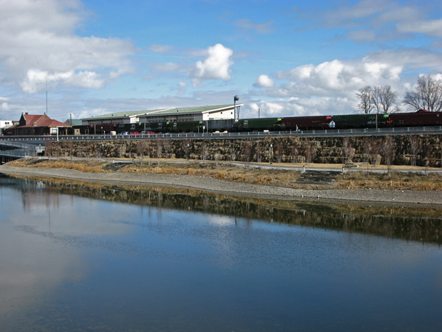
Here is the Sand Creek Byway today. While Vicki was at the site, a long train rumbled along the tracks, reminding her that train watching is a favorite activity in Sandpoint and train traffic is often throughout the day. Here the view extends from the waterfront, to the linear park, to the green wall, to the Byway, to the railroad tracks and to the buildings beyond, including the train depot, create rich collage of usage and experience. It is an amazing layering of activities and purposes within a very compact site.

Photo Credit: Idaho Airships Inc, courtesy of URS
Team Credits:
with
Runa/Sykes
Vicki Scuri SiteWorks with Mark Spitzer Designs (consulting architect)
Shapiro & Associates
Environmental History Company
Client:
Idaho Transportation Department
Reblogged this on Out Looking and commented:
This looks like a great use of infrastructure, as a platform to define space. Bridges define place, as Heidegger suggests. Nicely Done!